
See this visualization first on the Voronoi app.
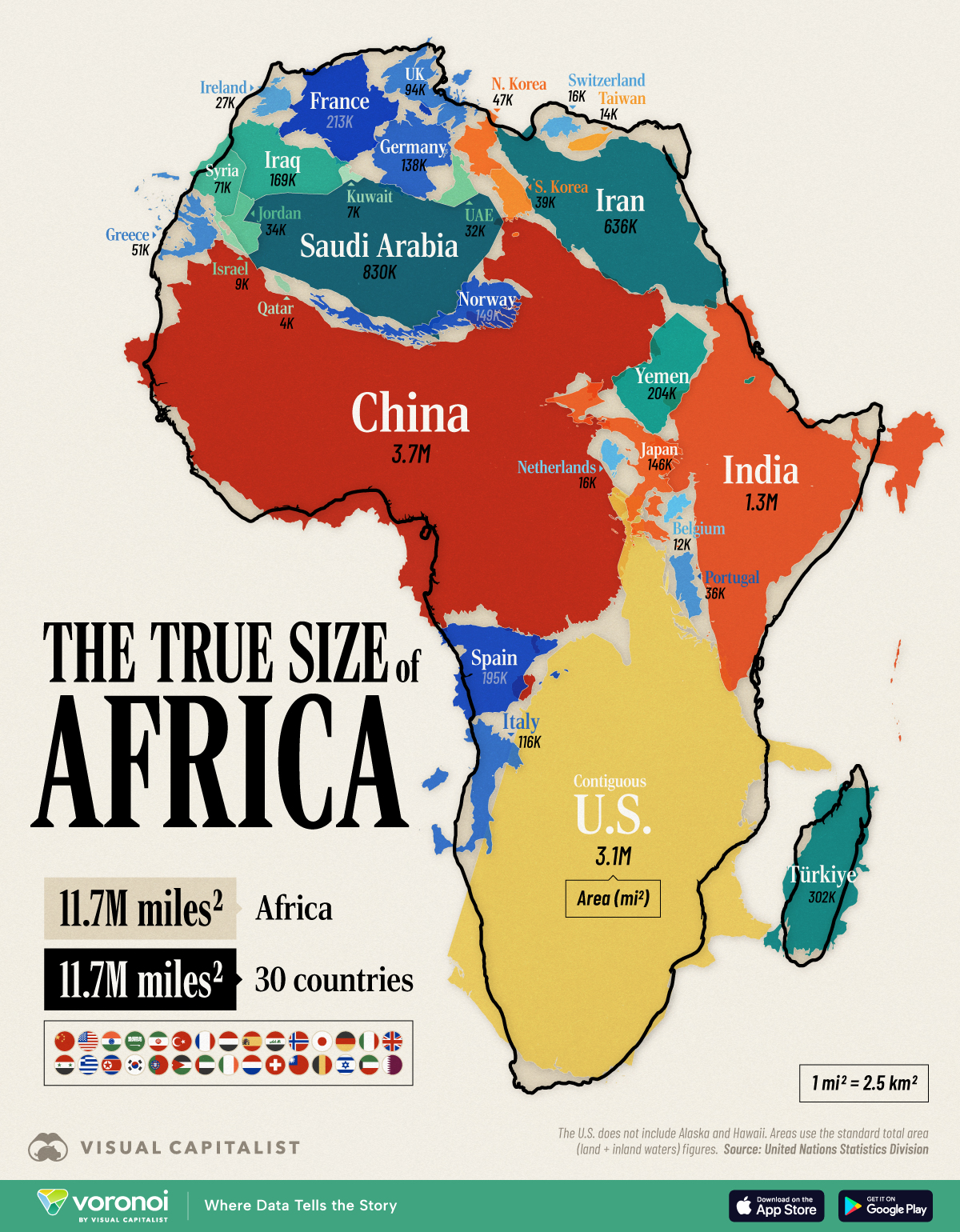
How Many Countries Fit in Africa? The Continent’s True Size
This was originally posted on our Voronoi app. Download the app for free on iOS or Android and discover incredible data-driven charts from a variety of trusted sources.
Key Takeaways
- The continent of Africa covers 11.7 million mi² (30.4 million km²), roughly equal to the size of 30 countries.
- These 30 include some of the world’s largest countries like the (contiguous) U.S., China, and India.
- However, the most common map projection, called the Mercator projection, makes Africa it appear smaller than actually is.
- The African Union has urged governments to not use it anymore as it gives the impression that Africa is “marginal” on the world stage.
- For reference, Africa is the second-largest continent, both by size and population (1.6 billion people).
Africa is vast.
So vast that its full scale can be hard to grasp by looking at most world maps.
The graphic above solves this by combining individual countries inside the continent’s area, showing that Africa’s landmass is on par with the (contiguous) U.S., China, India, and much of Western Europe combined.
Data for this visualization comes from UN Statistics Division and total area (land + inland waters) was used for this comparison.
Related: Using only land area changes the ranks of the world’s biggest countries.
Africa’s Area in Raw Numbers
At 11.7 million mi² (30.4 million km²), Africa is the world’s second-largest continent after Asia.
Put another way, it easily contains the contiguous U.S. (3.1M mi² / 8.1M km²) and China (3.7M mi² / 9.6M km² ) with room to spare.
| Country/Region | Total Area (mi²) | Readable Label | Total Area (km²) | Readable Label |
|---|---|---|---|---|
| Contiguous U.S. | 3,119,885 | 3.1M miles² | 8,080,464 | 8.1M km² |
| China | 3,705,407 | 3.7M miles² | 9,596,961 | 9.6M km² |
| India | 1,269,219 | 1.3M miles² | 3,287,263 | 3.3M km² |
| Saudi Arabia | 830,000 | 830K miles² | 2,149,690 | 2.1M km² |
| Iran | 636,372 | 636K miles² | 1,648,195 | 1.6M km² |
| Turkey | 302,455 | 302K miles² | 783,356 | 783K km² |
| France | 213,011 | 213K miles² | 551,695 | 552K km² |
| Yemen | 203,850 | 204K miles² | 527,968 | 528K km² |
| Spain | 195,364 | 195K miles² | 505,990 | 506K km² |
| Iraq | 169,235 | 169K miles² | 438,317 | 438K km² |
| Norway | 148,729 | 149K miles² | 385,207 | 385K km² |
| Japan | 145,937 | 146K miles² | 377,975 | 378K km² |
| Germany | 137,988 | 138K miles² | 357,386 | 357K km² |
| Italy | 116,348 | 116K miles² | 301,340 | 301K km² |
| UK | 93,628 | 94K miles² | 242,495 | 242K km² |
| Syria | 71,498 | 71K miles² | 185,180 | 185K km² |
| Greece | 50,949 | 51K miles² | 131,957 | 132K km² |
| North Korea | 46,541 | 47K miles² | 120,540 | 121K km² |
| South Korea | 38,750 | 39K miles² | 100,363 | 100K km² |
| Portugal | 35,603 | 36K miles² | 92,212 | 92K km² |
| Jordan | 34,495 | 34K miles² | 89,342 | 89K km² |
| UAE | 32,278 | 32K miles² | 83,600 | 84K km² |
| Ireland | 27,133 | 27K miles² | 70,273 | 70K km² |
| Netherlands | 16,164 | 16K miles² | 41,865 | 42K km² |
| Switzerland | 15,942 | 16K miles² | 41,290 | 41K km² |
| Taiwan | 13,976 | 14K miles² | 36,197 | 36K km² |
| Belgium | 11,849 | 12K miles² | 30,689 | 31K km² |
| Israel | 8,522 | 9K miles² | 22072 | 22K km² |
| Kuwait | 6,880 | 7K miles² | 17818 | 18K km² |
| Qatar | 4,473 | 4K miles² | 11586 | 12K km² |
| 30 Countries | 11,702,481 | 11.7M miles² | 30309286 | 30.3M km² |
| Africa | 11,730,000 | 11.7M miles² | 30370000 | 30.4M km² |
Add India’s 1.3M mi² (3.3M km²) and we’re still not close to filling the continent’s footprint.
In fact, it takes a total of 30 countries together—shown in the graphic above —to equal Africa’s total area, underscoring how massive the continent is in absolute terms.
Of course, country selection can change these numbers. If prioritizing Central and South American countries instead (like Mexico and Argentina,) the comparison could reduce to 18 entities.
Including Alaska and Hawaii would increase America’s footprint by 700,000 mi² (1.8M km²).
Why Your Wall Map Gets Africa Wrong
Many of us grew up looking at wall maps that use the Mercator projection.
This 16th-century design keeps straight lines for navigation but dramatically enlarges regions near the poles and compresses those near the equator.
Africa, which straddles the equator, is one of the biggest victims of this distortion.
Related: On a Mercator map, Greenland can appear almost as large as Africa. In reality, Africa is 14x bigger.
That discrepancy fuels common misconceptions about just how expansive Africa really is.
African Union Calls For Equal Projections Map
The African Union has asked international organizations to stop using the Mercator projection.
They say this size misrepresentation undermines the perceived global influence and importance of Africa and perpetuates stereotypes.
For example, the frequent use of the Mercator map in educational settings and media can lead many to unconsciously imagine Europe and North America as disproportionately significant.
Meanwhile Africa appears less substantial and “marginal.”
The map above also drives home another point. When discussing global development, trade, or climate impacts, treating Africa as a single bloc overlooks the continent’s enormous spatial and cultural complexity.
Learn More on the Voronoi App
If you enjoyed today’s post, check out Germany’s Economy Compared to 22 European Countries on Voronoi, the new app from Visual Capitalist.