![]()
See more visuals like this on the Voronoi app.
Use This Visualization
The World’s Largest Regional Seas
See visuals like this from many other data creators on our Voronoi app. Download it for free on iOS or Android and discover incredible data-driven charts from a variety of trusted sources.
Key Takeaways
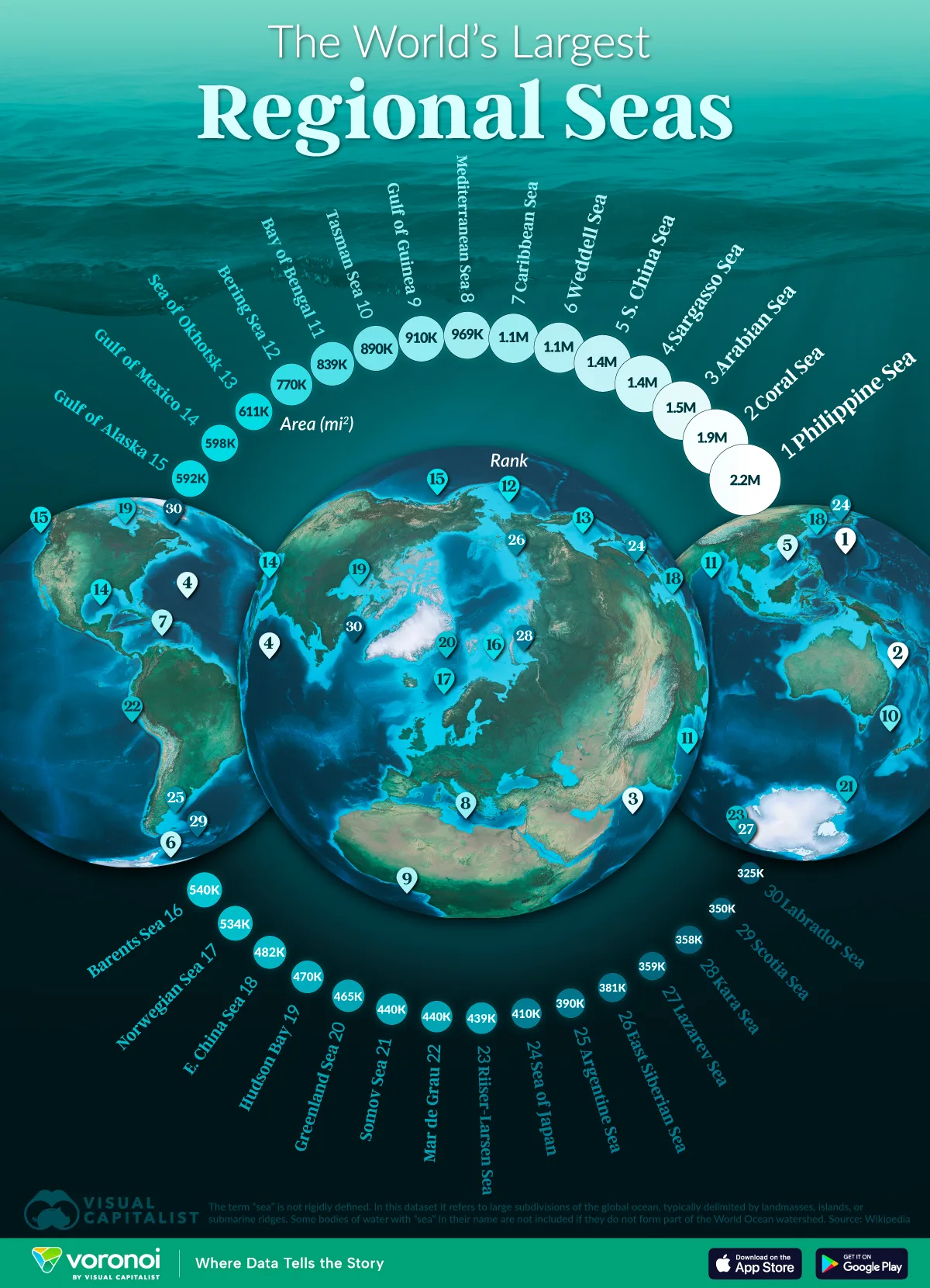
- The Philippine Sea is the world’s largest regional sea, covering nearly 5.7 million km².
- Many of the world’s largest seas play major roles in climate regulation, biodiversity, and global shipping routes.
The world’s largest regional seas span a wide range of climates, from the warm tropics to the frigid waters around Antarctica. They are major subdivisions of the global ocean system, often defined by surrounding landmasses or submarine ridges.
This visualization highlights the 30 largest regional seas on Earth by surface area, ranging from the vast Philippine Sea to the chilly Labrador Sea. The data for this visualization comes from Wikipedia.
The term “sea” is not rigidly defined, and in this dataset it refers primarily to large subdivisions of the global ocean rather than isolated inland water bodies. These boundaries often follow continental margins, island arcs, or oceanic ridges.
The Philippine and Coral Seas Dominate the Rankings
The Philippine Sea stands out as the world’s largest regional sea at nearly 5.7 million km², making it more than twice the size of the Mediterranean. Its vast expanse hosts some of the planet’s deepest ocean trenches and most active tectonic zones.
The neighboring Coral Sea, the second largest, is home to the Great Barrier Reef and is a major reservoir of marine biodiversity.
| Rank | Name | Area_km2 | Area_sq_mi |
|---|---|---|---|
| 1 | Philippine Sea | 5,695,000 | 2,199,000 |
| 2 | Coral Sea | 4,791,000 | 1,850,000 |
| 3 | Arabian Sea | 3,862,000 | 1,491,000 |
| 4 | Sargasso Sea | 3,500,000 | 1,400,000 |
| 5 | South China Sea | 3,500,000 | 1,400,000 |
| 6 | Weddell Sea | 2,800,000 | 1,100,000 |
| 7 | Caribbean Sea | 2,754,000 | 1,063,000 |
| 8 | Mediterranean Sea | 2,510,000 | 969,000 |
| 9 | Gulf of Guinea | 2,350,000 | 910,000 |
| 10 | Tasman Sea | 2,300,000 | 890,000 |
| 11 | Bay of Bengal | 2,172,000 | 839,000 |
| 12 | Bering Sea | 2,000,000 | 770,000 |
| 13 | Sea of Okhotsk | 1,583,000 | 611,000 |
| 14 | Gulf of Mexico | 1,550,000 | 598,000 |
| 15 | Gulf of Alaska | 1,533,000 | 592,000 |
| 16 | Barents Sea | 1,400,000 | 540,000 |
| 17 | Norwegian Sea | 1,383,000 | 534,000 |
| 18 | East China Sea | 1,249,000 | 482,000 |
| 19 | Hudson Bay | 1,230,000 | 470,000 |
| 20 | Greenland Sea | 1,205,000 | 465,000 |
| 21 | Somov Sea | 1,150,000 | 440,000 |
| 22 | Mar de Grau | 1,140,000 | 440,000 |
| 23 | Riiser-Larsen Sea | 1,138,000 | 439,000 |
| 24 | Sea of Japan | 1,050,000 | 410,000 |
| 25 | Argentine Sea | 1,000,000 | 390,000 |
| 26 | East Siberian Sea | 987,000 | 381,000 |
| 27 | Lazarev Sea | 929,000 | 359,000 |
| 28 | Kara Sea | 926,000 | 358,000 |
| 29 | Scotia Sea | 900,000 | 350,000 |
| 30 | Labrador Sea | 841,000 | 325,000 |
Strategic Waters in the Indian and Atlantic Oceans
The Arabian Sea and the South China Sea both rank within the top five and serve as critical hubs for global shipping. Their warm waters support major monsoon systems that shape regional climates and agriculture.
Further west, the Caribbean Sea and Gulf of Guinea play key roles in trade and energy transport.
Cold-Region Seas Cover Vast, Remote Areas
Several polar seas also make the list, including the Weddell, Barents, and Greenland Seas. These regions are essential for deep-water formation, a process that helps drive global ocean circulation.
Their extreme climates limit human activity, yet they store significant carbon and influence sea ice patterns. As climate change reshapes the poles, these remote seas will become even more important for understanding Earth’s shifting systems.
Learn More on the Voronoi App ![]()
If you enjoyed today’s post, check out The World’s Most Powerful Rivers on Voronoi, the new app from Visual Capitalist.