
See more visualizations like this on the Voronoi app.
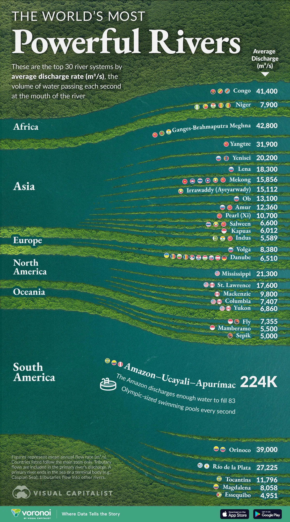
Ranked: The World’s Most Powerful Rivers
See visuals like this from many other data creators on our Voronoi app. Download it for free on iOS or Android and discover incredible data-driven charts from a variety of trusted sources.
Key Takeaways
- The Amazon is the most powerful river in the world with an average flow rate of 224,000 m³/s.
- Its discharge could fill more than 83 Olympic-sized swimming pools every single second.
- Missing from this chart is the Nile, which has a lower average discharge (3,075 m³/s) because of massive water loss to evaporation through the arid Sahara desert.
Rivers are the arteries of our planet, moving freshwater across continents and shaping entire ecosystems.
Our latest visualization ranks the world’s 30 most powerful rivers measured by their average flow rate, shining a spotlight on waterways whose sheer volume dwarfs anything humans can engineer.
The data for this visualization comes from Wikipedia’s compiled list of river discharges, which aggregates measurements from hydrological services and academic studies around the globe.
The Amazon’s Unmatched Output
At 224,000 m³ of water per second, the Amazon releases more flow than the next four rivers on the list combined.
If it were a pump, the river could fill 83 Olympic-sized swimming pools every second.
| Rank | River System | Region | Average Flow Rate (m³/s) |
Countries |
|---|---|---|---|---|
| 1 | Amazon–Ucayali–Apurímac | South America | 224,000 | PER, COL, BRA |
| 2 | Ganges-Brahmaputra-Meghna | Asia | 42,800 | IND, BGD, CHN |
| 3 | Congo | Africa | 41,400 | COD, COG, AGO |
| 4 | Orinoco | South America | 39,000 | VEN, COL |
| 5 | Yangtze (Chang Jiang) | Asia | 31,900 | CHN |
| 6 | Río de la Plata | South America | 27,225 | ARG, URY |
| 7 | Mississippi | North America | 21,300 | USA |
| 8 | Yenisei | Asia | 20,200 | MNG, RUS |
| 9 | Lena | Asia | 18,300 | RUS |
| 10 | St. Lawrence | North America | 17,600 | CAN, USA |
| 11 | Mekong | Asia | 15,856 | CHN, MMR, LAO, THA, KHM, VNM |
| 12 | Irrawaddy (Ayeyarwady) | Asia | 15,112 | MMR |
| 13 | Ob | Asia | 13,100 | RUS |
| 14 | Amur | Asia | 12,360 | CHN, RUS |
| 15 | Tocantins | South America | 11,796 | BRA |
| 16 | Pearl (Xi) | Asia | 10,700 | CHN |
| 17 | Mackenzie | North America | 9,800 | CAN |
| 18 | Volga | Europe | 8,380 | RUS |
| 19 | Magdalena | South America | 8,058 | COL |
| 20 | Niger | Africa | 7,900 | GIN, MLI, NER, BEN, NGA |
| 21 | Columbia | North America | 7,407 | USA, CAN |
| 22 | Fly | Oceania | 7,355 | PNG, IDN |
| 23 | Yukon | North America | 6,860 | CAN, USA |
| 24 | Salween | Asia | 6,600 | CHN, MMR, THA |
| 25 | Danube | Europe | 6,510 | DEU, AUT, SVK, HUN, HRV, SRB, ROU, BGR, MDA, UKR |
| 26 | Kapuas | Asia | 6,012 | IDN |
| 27 | Indus | Asia | 5,589 | CHN, IND, PAK |
| 28 | Mamberamo | Oceania | 5,500 | IDN |
| 29 | Sepik | Oceania | 5,000 | PNG |
| 30 | Essequibo | Oceania | 4,951 | GUY |
Note: Countries listed are along the main stem, not the full drainage basin. Tributary flows are not listed separately, they are accounted for in the discharge of the primary outlet river system. A primary river is one that terminates in the sea/ocean or a terminal water body (e.g., the Caspian Sea), whereas tributaries flow into another river.
The Amazon’s vast drainage basin—covering an area roughly the size of the contiguous U.S.—collects rainfall from nine countries.
The river’s low-lying gradient allows that water to surge unimpeded toward the Atlantic.
Even in its driest months, the Amazon moves enough water to equal the peak flow of most other major rivers, underscoring its outlier status in the global hydrological system.
Related: The Amazon rainforest was named after the river. See how the forest plays a critical role in global food supply.
Asia’s Dense Network of Giant Waterways
While South America claims the undisputed champion in the Amazon, Asia dominates the rest of the top 10.
The Ganges-Brahmaputra-Meghna, Yangtze, Yenisei, and Lena systems all exceed 18,000 m³/s.
These rivers drain the towering Himalayas and the Siberian taiga, channeling seasonal snowmelt and monsoon rains into fertile floodplains that support over a billion people.
Rapid economic growth along their banks makes the stability of their flow regimes critical.
From irrigation in India’s breadbasket to hydropower in China’s industrial heartlands, Asia’s great rivers remain lifelines for energy and food security.
Related: The Indo–Gangetic plain supports 9-14% of the world’s entire population.
The Longest Rivers Aren’t Always the Most Powerful
Africa’s mighty Congo is the lone representative from the continent in the top five, but its 41,400 m³/s rank shows how the equatorial rainforests centralize runoff into a single channel.
North America’s Mississippi and St. Lawrence illustrate how large basins paired with moderate precipitation translate into respectable yet smaller discharges.
Meanwhile, Europe’s Volga and Danube barely crack the list, reflecting the continent’s temperate climate and complex network of dams and diversions.
Finally, rivers in Oceania such as the Fly, Mamberamo, and Sepik punch above their watershed size thanks to Papua New Guinea’s torrential rainfall, reminding us that local climate can outweigh geography.
Notable in its absence is the world’s longest river, the Nile. It has a lower average discharge (3,075 m³/s) because of massive water loss to evaporation through the arid Sahara desert.
Learn More on the Voronoi App
If you enjoyed today’s post, check out The Wettest and Driest Countries on Voronoi, the new app from Visual Capitalist.