![]()
See this visualization first on the Voronoi app.
Use This Visualization
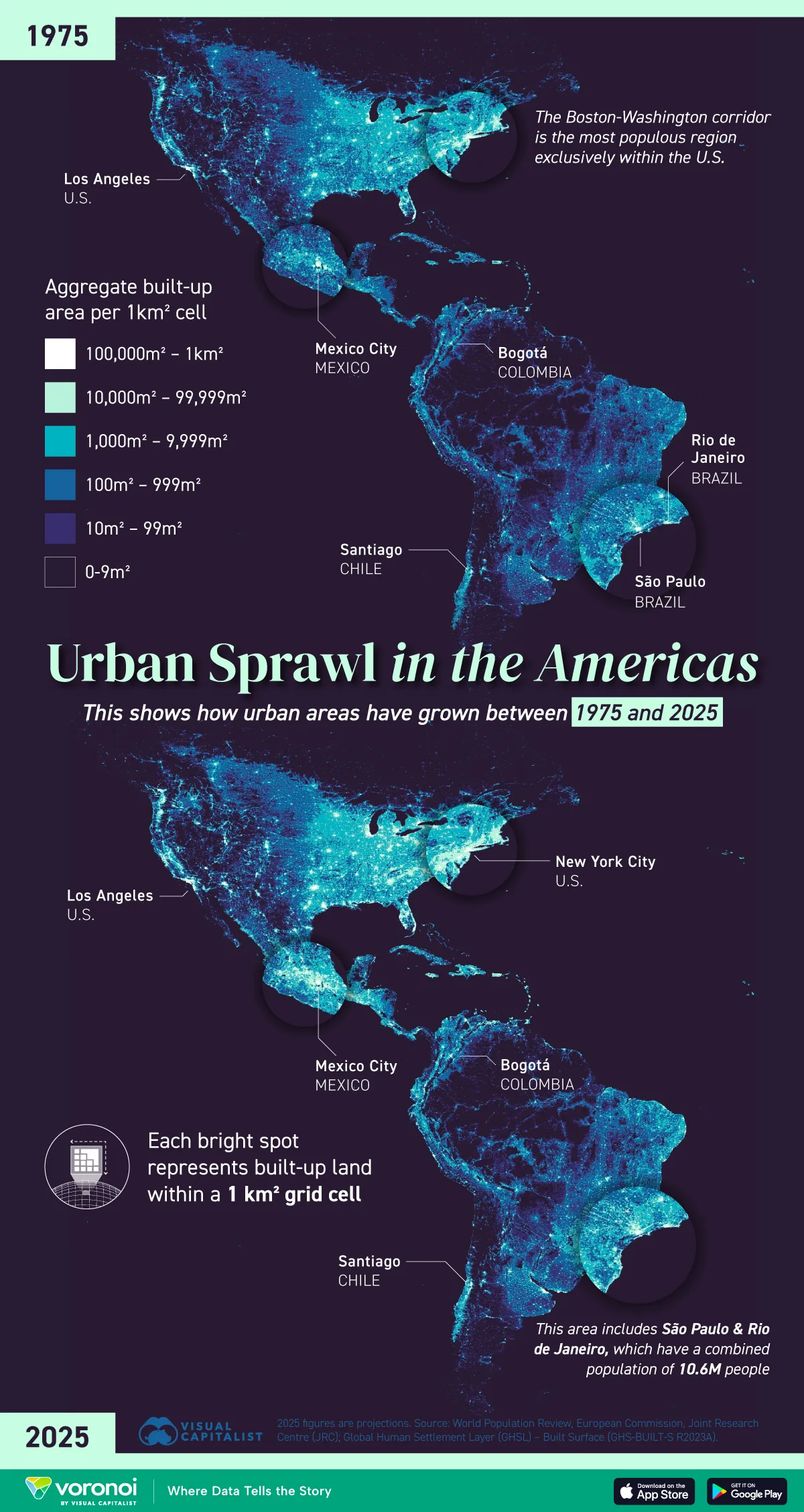
How Cities in the Americas Have Grown Since 1975
This was originally posted on our Voronoi app. Download the app for free on iOS or Android and discover incredible data-driven charts from a variety of trusted sources.
Key Takeaways
- North America’s build-up since 1975 has been focused around major corridors such as the U.S. East Coast and the Great Lakes
- Urban concentration has also increased significantly in Mexico and Brazil; population in both countries has roughly doubled since 1975
Urbanization in the Americas has seen remarkable changes since 1975. This visualization shows how major metropolitan areas across North, Central, and South America have expanded in population and density over the past five decades.
While U.S. cities grew steadily, cities in Latin America experienced some of the most dramatic urban booms. The data for this visualization comes from World Population Review.
Latin America’s Explosive Urban Growth
Cities like São Paulo, Mexico City, and Bogotá have more than doubled in population since 1975. São Paulo, for instance, expanded from under 10 million to nearly 23 million. This growth reflects broader urbanization trends in Latin America, where rural-to-urban migration has accelerated due to economic shifts, better job opportunities, and access to services in cities.
| Metro Area | Country | 1975 | 2025 |
|---|---|---|---|
| Sao Paulo | Brazil | 9,614,000 | 22,990,000 |
| Rio de Janeiro | Brazil | 7,733,000 | 13,923,000 |
| New York City | USA | 15,880,000 | 19,154,000 |
| Los Angeles | USA | 8,926,000 | 12,678,000 |
| Mexico City | Mexico | 10,734,000 | 22,752,000 |
| Santiago | Chile | 3,138,000 | 6,999,000 |
| Bogota | Colombia | 3,040,000 | 11,796,000 |
Steady Expansion in U.S. Cities
U.S. metro areas such as New York City and Los Angeles saw significant but more moderate growth. NYC grew from 15.9 million in 1975 to over 19 million in 2025. The East Coast, Great Lakes, and Southern California corridors have remained population magnets.
Canada’s Sparse Urban Footprint
Canada, despite its vast landmass, remains lightly urbanized outside of key areas like Toronto and Vancouver. Geographic barriers and a harsh climate have concentrated most of its population in a narrow southern band.
Learn More on the Voronoi App ![]()
If you enjoyed today’s post, check out The Total Area of Every Country, in One Chart on Voronoi, the new app from Visual Capitalist.