Content originally published at iBankCoin.com
Imagine yourself hosting a party and a hurricane filed with nuclear bombs showed up and blew away your little condo, like the big bad wolf did to that little piggy straw house. According to the Miami Beach Mayor, that's exactly what Hurricane Irma is going to do when it lands in Florida this weekend. He's warning residents to 'get out' because Hurricane Irma is a 'nuclear hurricane.'
Miami Beach Mayor: 'This is a nuclear hurricane' pic.twitter.com/9NjeE6Dpod
— The_Real_Fly (@The_Real_Fly) September 7, 2017
https://www.youtube.com/watch?v=oyepoW-SUM4
As an incentive, hotels and condos are shutting down power to force people to leave.
The Governor of Florida, Rick Scott, warned residents that 'the storm surge can kill you', pleading with people to leave.
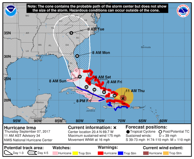
It's important to note, Hurricane Irma is sustaining 180mph winds for the longest time in history and is now the size of Texas.
https://www.youtube.com/watch?v=AM3BRRXvz_w
Dr. Masters from Wunderground opines.
Florida: Where and when Irma makes its right-hand turn will largely determine its track with respect to the Florida peninsula. Based on recent ensemble models (in which a large number of parallel runs are carried out to simulate uncertainty in the atmosphere), it is still possible that Irma could take a south-to-north inland track across the Florida peninsula, or a track that stays just east of Florida’s East Coast. However, it appears most likely that Irma will hug the state's East Coast from south to north, potentially moving inland over some sections. This type of track is far different from those of Hurricane Andrew (1992) and Katrina (2005), which moved from east to west across the Miami metro area. A south-to-north track would affect a much larger part of this elongated metroplex. In an interview published in Capital Weather Gang in August, Bryan Norcross touches on the many issues that a hurricane like Irma could bring to South Florida, which has not experienced a storm this strong in 25 years.
Depending on Irma’s track, hurricane conditions could extend well inland, as well as northward along the length of the peninsula. The entire Florida peninsula is within the five-day cone of uncertainty in the official NHC forecast, and all residents of these areas should pay close attention to the progress of Irma, especially along Florida’s East Coast. NHC may issue Hurricane Watches for parts of South Florida and the Keys on Thursday.
Irma’s intensity will likely undergo fluctuations over the next couple of days, but intensity models show only gradual weakening, and NHC maintains Irma as a Cat 5 storm through Friday. Wind shear is predicted to remain low to moderate along Irma’s path until Saturday, and Irma will be passing over waters that are as warm or slightly warmer than its current environment (see discussion in our Tuesday PM post). Land interaction with Cuba could weaken Irma somewhat, but we must assume that Irma will be at least a Category 4 as it nears South Florida on Sunday, as predicted by NHC.
More from Dr. Hanson
—Irma is likely to be at least a Category 4 when it nears Southeast Florida on Sunday. There is nothing in the atmosphere on the large scale that would be expected to produce significant weakening before at least Saturday. As Irma moves just north of Hispaniola on Thursday, and offshore or just over the north coast of Cuba on Friday into Saturday, the interaction with land may disrupt Irma somewhat, as noted above. On the other hand, water temperatures will remain steady or slightly increase along Irma’s path, which is favorable for maintaining Irma’s strength. Irma may experience moderate wind shear by Sunday (around 15 knots), but it is safest to assume that Irma will maintain at least Category 4 intensity on its final approach to Florida, as reflected in NHC’s 11 am Thursday forecast. More significant weakening is expected from Sunday into Monday, because of increasing wind shear and land interaction. Irma is still predicted to approach the Southeast coast of GA/SC as a Category 3 hurricane.
—Regardless of its strength at final landfall, Irma has the potential to generate a catastrophic storm surge across the Southeast coast from northern Florida to South Carolina. Under almost all track scenarios for Irma, the vast amount of water being pushed northwest by the storm is expected to slam into the Southeast coast and produce a devastating storm surge. Even if Irma’s winds decrease as expected by Monday, this water will already be in motion, packed with tremendous momentum. From our Wednesday PM post on the storm surge potential: “Even areas up to a hundred miles to the north of where the center makes landfall could potentially see record storm surges. The area of most concern is the northern coast of Florida, the coast of Georgia, and the southern coast of South Carolina, due to the concave shape of the coast, which will act to funnel and concentrate the storm surge to ridiculous heights.” See our Wednesday post for more details.
Within the storm surge warning area along the Southeast Florida coast, water levels above ground (inundation) could reach 5 to 10 feet, according to official NHC storm surge guidance as of 11 am EDT Thursday. Storm surge expert Dr. Hal Needham has launched a storm surge website for Miami with details on the city's surge history and surge potential.?
—Large parts of the Florida peninsula would experience damaging winds on any of the most likely tracks for Irma. Irma’s hurricane-force winds now extend up to 50 miles from its center, and that radius will increase over time. Even after Irma’s top winds weaken, the wind field will gradually expand over time. Tropical-storm-force winds extend up to 160 miles from Irma’s center, which would be enough to straddle the entire Florida peninsula. In 2005, Hurricane Wilma crossed the state at Category 2/3 strength from Cape Romano to Jupiter. Even though Wilma’s center was 60 miles north of Fort Lauderdale, the city’s downtown experienced significant damage, with many glass facades sheared off by high wind. Floridians should be prepared for massive loss of windows and glass facades with Irma, especially if it tracks near or over Florida’s East Coast. It's worth noting that Broward County—population 1.9 million—has not experienced a direct hit from a major hurricane since 1947. At that point, the county’s population was about 85,000.
Additionally, both Jose and Katia are rapidly developing. Should all three storms make landfall this weekend, it would be the first time 3 storms hit simultaneously dating back to 1851.