![]()
See this visualization first on the Voronoi app.
Use This Visualization
Map: India’s Population Density Patterns
This was originally posted on our Voronoi app. Download the app for free on iOS or Android and discover incredible data-driven charts from a variety of trusted sources.
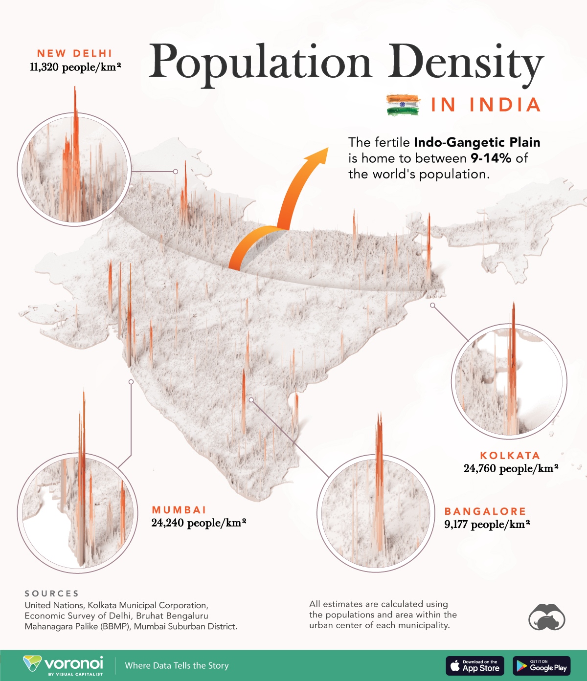
India’s population has now grown to 1.42 billion people, topping China as the world’s most populous country. Spread over 1.27 million square miles (3.28 million km²), India’s average density comes in at 1,118 people per square mile (or 433 people/km²).
However, this already significant number can jump even higher, as seen in this population density map based on data from various government sources.
Ranked: India’s Largest Cities
Sprawling metropolises, Kolkata and Mumbai are incredibly dense, with over 24,000 people living within a square kilometer. This is significantly higher than Shanghai, which has only 16,982 people/km².
Both cities are erstwhile British trading outposts that grew to economic powerhouses at the height of the empire.
For more complete reference, here is a list of India’s most populous cities, corresponding neatly with the spikes on the map.
| Rank | City | State/Union Territory | 2024 Population Estimates |
|---|---|---|---|
| 1 | New Delhi | Delhi* | 34M |
| 2 | Mumbai | Maharashtra | 22M |
| 3 | Kolkata | West Bengal | 16M |
| 4 | Bengaluru | Karnataka | 14M |
| 5 | Chennai | Tamil Nadu | 12M |
| 6 | Hyderabad | Telangana | 11M |
| 7 | Ahmadabad | Gujarat | 9M |
| 8 | Surat | Gujarat | 8M |
| 9 | Pune | Maharashtra | 7M |
| 10 | Jaipur | Rajasthan | 4M |
| 11 | Kozhikode | Kerala | 4M |
| 12 | Malappuram | Kerala | 4M |
| 13 | Lucknow | Uttar Pradesh | 4M |
| 14 | Thrissur | Kerala | 4M |
| 15 | Kochi | Kerala | 4M |
| 16 | Indore | Madhya Pradesh | 3M |
| 17 | Kanpur | Uttar Pradesh | 3M |
| 18 | Nagpur | Maharashtra | 3M |
| 19 | Coimbatore | Tamil Nadu | 3M |
| 20 | Thiruvananthapuram | Kerala | 3M |
| 21 | Patna | Bihar | 3M |
| 22 | Bhopal | Madhya Pradesh | 3M |
| 23 | Agra | Uttar Pradesh | 3M |
| 24 | Kannur | Kerala | 2M |
| 25 | Visakhapatnam | Andhra Pradesh | 2M |
| 26 | Vadodara | Gujarat | 2M |
| 27 | Nashik | Maharashtra | 2M |
| 28 | Vijayawada | Andhra Pradesh | 2M |
| 29 | Kollam | Kerala | 2M |
| 30 | Rajkot | Gujarat | 2M |
| 31 | Ludhiana | Punjab | 2M |
| 32 | Madurai | Tamil Nadu | 2M |
| 33 | Raipur | Chhattisgarh | 2M |
| 34 | Meerut | Uttar Pradesh | 2M |
| 35 | Varanasi | Uttar Pradesh | 2M |
| 36 | Srinagar | Jammu & Kashmir* | 2M |
| 37 | Tiruppur | Tamil Nadu | 2M |
| 38 | Jamshedpur | Jharkhand | 2M |
| 39 | Aurangabad | Maharashtra | 2M |
| 40 | Jodhpur | Rajasthan | 2M |
| 41 | Ranchi | Jharkhand | 2M |
| 42 | Kota | Rajasthan | 2M |
| 43 | Jabalpur | Madhya Pradesh | 2M |
| 44 | Asansol | West Bengal | 2M |
| 45 | Gwalior | Madhya Pradesh | 2M |
| 46 | Allahabad | Uttar Pradesh | 2M |
| 47 | Amritsar | Punjab | 1M |
| 48 | Dhanbad | Jharkhand | 1M |
| 49 | Bareilly | Uttar Pradesh | 1M |
| 50 | Aligarh | Uttar Pradesh | 1M |
| 51 | Moradabad | Uttar Pradesh | 1M |
| 52 | Mysore | Karnataka | 1M |
| 53 | Durg-Bhilainagar | Chhattisgarh | 1M |
| 54 | Bhubaneswar | Odisha | 1M |
| 55 | Tiruchirappalli | Tamil Nadu | 1M |
| 56 | Chandigarh | Chandigarh* | 1M |
| 57 | Saharanpur | Uttar Pradesh | 1M |
| 58 | Hubli-Dharwad | Karnataka | 1M |
| 59 | Guwahati | Assam | 1M |
| 60 | Salem | Tamil Nadu | 1M |
| 61 | Siliguri | West Bengal | 1M |
| 62 | Jalandhar | Punjab | 1M |
| 63 | Solapur | Maharashtra | 1M |
| 64 | Warangal | Telangana | 1M |
| 65 | Dehradun | Uttarakhand | 1M |
*Union territories. Names may have changed since this data was published. Source: UN World Urbanization Prospects (2018).
Just south of the Himalayas lies the Indo-Gangetic Plain, one of the most populated regions on Earth. Rivers fed by the massive mountain range make this region an exceptionally fertile agricultural zone.
Most of the plain lies in Uttar Pradesh, India’s most populous state and home to 240 million people. This makes it comparable to the size of Pakistan, the fifth most populous country in the world.
Meanwhile, a rare low density area can be spotted in the northeast of the country. This area is heavily forested and abound with several national parks, providing habitat for animals like leopards, rhinos, and water buffalos.
The post See India’s Population Density Visualized on a 3D Map appeared first on Visual Capitalist.