You are here

Houston

OpenCalais Metadata: Latitude: 
29.7631
OpenCalais Metadata: Longitude: 
-95.3631
OpenCalais Metadata: ContainedByState: 
Texas

Army Begins Releasing Water From 2 Houston Dams, Flooding Thousands Of Nearby Homes
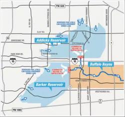
Army Begins Releasing Water From 2 Houston Dams, Flooding Thousands Of Nearby Homes

The US Army Corps of Engineers began releasing water into the Buffalo Bayou - the main body of water running through Houston - from two flood-control dams whose water level has risen too rapidly, a move that will flood thousands of nearby homes. Emergency workers said they began to release water from the Addicks and Barker dams located 17 miles west of downtown Houston early Monday to prevent uncontrollable flooding of the Houston metropolitan area from torrential rains released by Tropical Storm Harvey, according to ABC News.
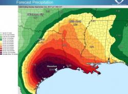
Shocking Drone Footage Shows Harvey's "Unprecedented" Devastation, "No Parallel To Any Rainstorm In US History"

Shocking Drone Footage Shows Harvey's "Unprecedented" Devastation, "No Parallel To Any Rainstorm In US History"

Based on the number of people affected, amount of water involved, and other factors, meteorologists have warned, there may be no parallel available to any other rainstorm in U.S. history as Mashable's Andrew Freeman reports Tropical Storm Harvey has dropped more than 11 trillion gallons of water on Texas, triggering catastrophic, unprecedented flooding in the Houston area.

Houston: The "Surreal" Before And After Photo

Houston: The "Surreal" Before And After Photo

Courtesy of Weather Channel weather producer, Matthew Sitkowski, here is a photo of what Houston's East Loop at Market Street on the I-610 looks like right now. As Sitkowski says, "this image and the forecast of what is still to fall.... This is surreal." He is right: we added a photo of the same location from February 2016 to show the "before and after." Here is the result:

The following time-lapse video shows the Buffalo Bayou next to Houston rising over the past day...

Pages