![]()
See this visualization first on the Voronoi app.
Use This Visualization
Mapped: The Population Density of France
This was originally posted on our Voronoi app. Download the app for free on iOS or Android and discover incredible data-driven charts from a variety of trusted sources.
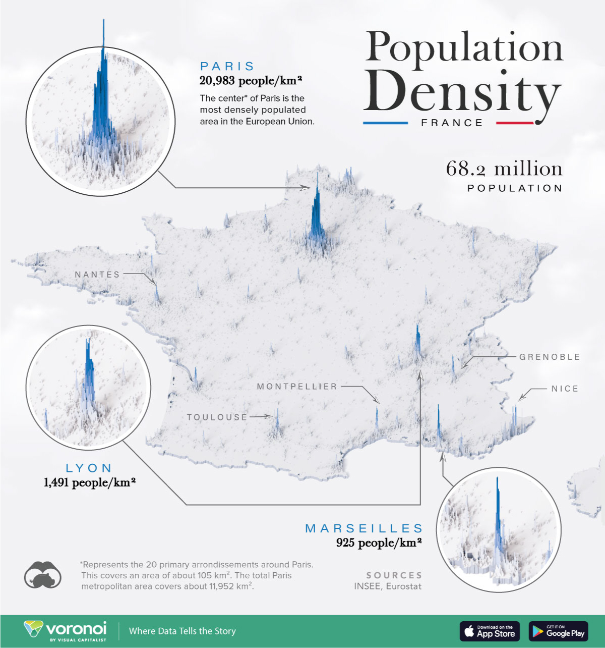
France lies between the Atlantic Ocean and the Mediterranean Sea, featuring a landscape of low-lying plains punctuated by the Alps and the Pyrenees mountains.
The Paris region and Hauts-de-France house roughly a third of the country’s population, while the cities of Lyon and Marseille rank among the most densely populated areas in the country. Overall, the most densely populated regions fall in eastern France.
This graphic shows France’s population density, based on data from various government sources.
Ranked: France’s 10 Most Populous Cities
Below, we show the largest cities in France, Europe’s second-largest economy, standing at a population of 68.2 million people:
| Rank | City | 2024 Population Estimates |
|---|---|---|
| 1 | Paris | 2,138,551 |
| 2 | Marseille | 794,811 |
| 3 | Lyon | 472,317 |
| 4 | Toulouse | 433,055 |
| 5 | Nice | 338,620 |
| 6 | Nantes | 277,269 |
| 7 | Strasbourg | 274,845 |
| 8 | Montpellier | 248,252 |
| 9 | Bordeaux | 231,844 |
| 10 | Lille | 228,328 |
With a population of 2.1 million, Paris is the most densely populated city not only in France, but the wider European region, at 20,983 people per square kilometer.
This central area of Paris, covering the 20 arrondissements, has a population that is more than five times as concentrated as the City of London. Beyond this perimeter, the Greater Paris Metropolis, comprising 131 communes, houses 7.2 million people.
As a leading economic hub in France, Lyon is the second-most densely populated in the country, at 1,491 people per square kilometer. With one of the strongest GDPs in Europe, the city creates 10,000 new businesses annually across a highly diversified economy. Major sectors in the city include machinery, pharmaceuticals, chemicals, and energy.
As the fifth-biggest metropolitan in the country, Nice’s primary economic driver is tourism. Located on the eastern coastline of France, roughly 40% of residents are employed directly or indirectly from the tourism industry. This is thanks to its rich architectural history and idyllic beaches in the French Riviera.
By contrast, the least densely populated areas of France fall within an area known as the “low-density diagonal”. Within this area located in the middle of the country, there are approximately 30 inhabitants per square kilometer. These provincial towns began emptying out in the 19th century with the emergence of industrialization. Often characterized by older residents and fewer job opportunities, this area continues to face a declining population.
The post Mapped: The Population Density of France appeared first on Visual Capitalist.