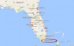
Two Nuclear Power Plants In Florida Are Directly In The Path Of Hurricane Irma

Authored by Michael Snyder via The American Dream blog,

Authored by Michael Snyder via The American Dream blog,

Authored by Sarah Burris via RawStory.com,
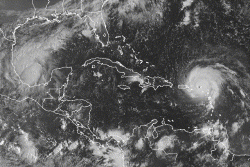
Hurricane Harvey was a tragic nightmare that hit the Texas shores with force and then lingered for days, dumping truck-loads of rain on a city ill-equipped to handle it. Florida is next, and if predictions are accurate, Hurricane Irma is going to be far worse than Houston was, and worse than anyone has prepared for.

Authored by Dale Steinreich viaThe Mises Institute,
As the floodwaters brought by Hurricane Harvey last week recede and new hurricane Irma moves slowly toward the Eastern U.S., it might be edifying to review how millions of Americans, despite federal anti-flood efforts, came to live and work in hazardous to dangerous flood-prone areas.

Content originally published at iBankCoin.com
I will not pretend to be a scientist in this blog, or even claim to know the very first thing about global warming or lack thereof. I am more interested in human narratives, how they are woven, and the basis from which they were formed. Just like in stocks, when listening to an analyst, I like to know the historical performance of his/her previous picks.